
Thank you for supporting this site ❤️
Make a donation
Make a donation
Gear up for your next adventure:
As an Amazon Associate, this site earns from qualifying purchases at no extra cost to you.
Tucsipampa topographic map
Click on the map to display elevation.
Thank you for supporting this site ❤️
Make a donation
Make a donation
Gear up for your next adventure:
As an Amazon Associate, this site earns from qualifying purchases at no extra cost to you.
About this map
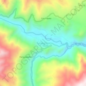
Name: Tucsipampa topographic map, elevation, terrain.
Location: Tucsipampa, Lircay, Angaraes, Huancavelica, Perú (-13.02008 -74.80770 -12.98008 -74.76770)
Average elevation: 12,103 ft
Minimum elevation: 11,083 ft
Maximum elevation: 13,698 ft
Thank you for supporting this site ❤️
Make a donation
Make a donation
Gear up for your next adventure:
As an Amazon Associate, this site earns from qualifying purchases at no extra cost to you.