Geolocate

Fort River topographic map

Click on the map to display elevation.

About this map

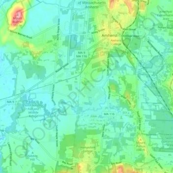
Name: Fort River topographic map, elevation, terrain.

Location: Fort River, Amherst, Hampshire County, Massachusetts, United States (42.32512 -72.58509 42.37868 -72.48754)

Average elevation: 194 ft

Minimum elevation: 102 ft

Maximum elevation: 518 ft

Hampshire County trails, hiking, mountain biking, running and outdoor activities

Other topographic maps

Click on a map to view its topography, its elevation and its terrain.

Cushman

United States > Massachusetts > Hampshire County > Amherst

Average elevation: 338 ft

Gear up for your next adventure:

😴Insulated Sleeping Pads - Compact and warm pads for high-elevation camping
📚USA Hiking Guide Books - Top trail guides and map books
📡GPS Antenna Upgrade - Enhance GPS reception in remote terrain
📡Handheld GPS Device - Reliable handheld GPS for outdoor navigation
🔪Outdoor Multitools - Essential survival tools for gear repair and field use

As an Amazon Associate, this site earns from qualifying purchases at no extra cost to you.