Plano topographic map
Interactive map
Click on the map to display elevation.
About this map
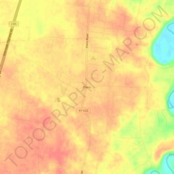
Name: Plano topographic map, elevation, terrain.
Location: Plano, Warren County, Kentucky, 42102, United States (36.86032 -86.43832 36.90032 -86.39832)
Average elevation: 597 ft
Minimum elevation: 459 ft
Maximum elevation: 646 ft
Other topographic maps
Click on a map to view its topography, its elevation and its terrain.
Bowling Green
United States > Kentucky > Warren County
Bowling Green, Warren County, Kentucky, 42101, United States
Average elevation: 554 ft
Rockfield
United States > Kentucky > Warren County
Rockfield, Warren County, Kentucky, 42274, United States
Average elevation: 587 ft
Richardsville
United States > Kentucky > Warren County
Richardsville, Warren County, Kentucky, United States
Average elevation: 597 ft
Alvaton
United States > Kentucky > Warren County
Alvaton, Warren County, Kentucky, 42122, United States
Average elevation: 597 ft
Smiths Grove
United States > Kentucky > Warren County
Smiths Grove, Warren County, Kentucky, United States
Average elevation: 633 ft
Springhill
United States > Kentucky > Warren County > Bowling Green > Springhill
Springhill, Bowling Green, Warren County, Kentucky, 42101-1000, United States
Average elevation: 509 ft