Geolocate

Hanover topographic map

Click on the map to display elevation.

About this map

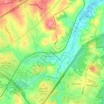
Name: Hanover topographic map, elevation, terrain.

Location: Hanover, Howard County, Maryland, 21076, United States (39.17289 -76.74414 39.21289 -76.70414)

Average elevation: 138 ft

Minimum elevation: 7 ft

Maximum elevation: 285 ft

Howard County trails, hiking, mountain biking, running and outdoor activities

Other topographic maps

Click on a map to view its topography, its elevation and its terrain.

Scaggsville

United States > Maryland > Howard County > Scaggsville

Average elevation: 364 ft

Wilde Lake

United States > Maryland > Howard County > Columbia

Average elevation: 374 ft

Gear up for your next adventure:

🖼️Topo Map Wall Art - Decorative topographic prints of famous peaks and regions
📦Gear Storage Bags - Organize and protect outdoor equipment
🛠️Outdoor Gear Repair Kit - Essential tools to fix gear on the trail
🪶Multi‑Purpose Knife - Useful blade for camp and trail
📌Outdoor GPS Map App - Apps and devices for digital topographic navigation

As an Amazon Associate, this site earns from qualifying purchases at no extra cost to you.