Geolocate

Sevilla topographic map

Click on the map to display elevation.

About this map

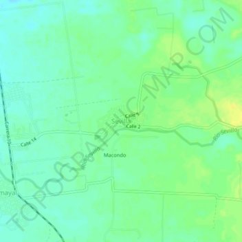
Name: Sevilla topographic map, elevation, terrain.

Location: Sevilla, Zona Bananera (Prado Sevilla), Magdalena, Colombia (10.74355 -74.15904 10.78355 -74.11904)

Average elevation: 79 ft

Minimum elevation: 49 ft

Maximum elevation: 115 ft

Gear up for your next adventure:

📶Satellite Messenger - Communication device off‑grid
🪶Camping Sleeping Pad - Comfortable sleeping pad for backpacking
🕶️GPS Smartphone Mount - Secure mount for phone navigation
📡GPS Antenna Upgrade - Enhance GPS reception in remote terrain
🎒Trail Energy Bars - High‑calorie bars for hiking energy

As an Amazon Associate, this site earns from qualifying purchases at no extra cost to you.