
Make a donation
Gear up for your next adventure:
As an Amazon Associate, this site earns from qualifying purchases at no extra cost to you.
Feldkahl topographic map
Click on the map to display elevation.
Make a donation
Gear up for your next adventure:
As an Amazon Associate, this site earns from qualifying purchases at no extra cost to you.
About this map
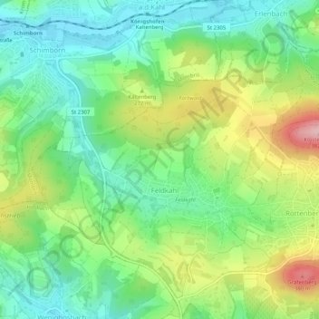
Name: Feldkahl topographic map, elevation, terrain.
Location: Feldkahl, Hösbach, Landkreis Aschaffenburg, Bayern, Deutschland (50.03206 9.18754 50.05607 9.23808)
Average elevation: 804 ft
Minimum elevation: 568 ft
Maximum elevation: 1,237 ft
Make a donation
Gear up for your next adventure:
As an Amazon Associate, this site earns from qualifying purchases at no extra cost to you.
Other topographic maps
Click on a map to view its topography, its elevation and its terrain.
Feldkahl
Deutschland > Bayern > Landkreis Aschaffenburg > Hösbach
Das Kirchdorf Feldkahl liegt im mittleren Kahlgrund am gleichnamigen Bach Feldkahl zwischen Rottenberg und Schimborn. Der topographisch höchste Punkt der Dorfgemarkung befindet sich an der Feldkahler Kapelle nordöstlich des Ortes am Klosterberg mit 332 m ü. NHN, der niedrigste liegt an der Feldkahl auf 193…
Average elevation: 797 ft
Münchhof
Deutschland > Bayern > Landkreis Aschaffenburg > Hösbach > Wenighösbach
Average elevation: 709 ft
Winzenhohl
Deutschland > Bayern > Landkreis Aschaffenburg > Hösbach
Das Dorf Winzenhohl liegt auf 220 m ü. NN an der Kreisstraße 2 zwischen Hösbach-Bahnhof und Haibach am Winzenhohler Bach. Der topographisch höchste Punkt der Dorfgemarkung ist der Gipfel des Kellerberges westlich des Ortes mit 330 m ü. NN, der niedrigste Punkt liegt an der Aschaff auf 147 m ü. NN. Durch…
Average elevation: 748 ft