
Make a donation
Gear up for your next adventure:
As an Amazon Associate, this site earns from qualifying purchases at no extra cost to you.
Moriat topographic map
Click on the map to display elevation.
Make a donation
Gear up for your next adventure:
As an Amazon Associate, this site earns from qualifying purchases at no extra cost to you.
About this map
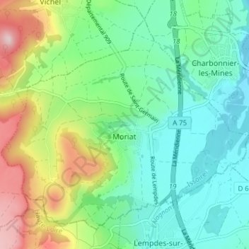
Name: Moriat topographic map, elevation, terrain.
Average elevation: 1,637 ft
Minimum elevation: 1,325 ft
Maximum elevation: 2,356 ft
Make a donation
Gear up for your next adventure:
As an Amazon Associate, this site earns from qualifying purchases at no extra cost to you.
Other topographic maps
Click on a map to view its topography, its elevation and its terrain.
Pissis
Francia > Auvergne-Rhône-Alpes > Puy-de-Dôme > Condat-lès-Montboissier
Average elevation: 2,792 ft
Fontclairant
Francia > Auvergne-Rhône-Alpes > Puy-de-Dôme > Aydat > Fontclairant
Average elevation: 3,114 ft
Make a donation
Gear up for your next adventure:
As an Amazon Associate, this site earns from qualifying purchases at no extra cost to you.
La Ferrere
Francia > Auvergne-Rhône-Alpes > Puy-de-Dôme > Saint-Alyre-d'Arlanc
Average elevation: 2,999 ft