
Make a donation
Gear up for your next adventure:
As an Amazon Associate, this site earns from qualifying purchases at no extra cost to you.
Aubazines topographic map
Click on the map to display elevation.
Make a donation
Gear up for your next adventure:
As an Amazon Associate, this site earns from qualifying purchases at no extra cost to you.
Aubazines
The lowest altitude of the commune is 126 metres in the west where the Corrèze leaves the commune. The highest points are 520 metres high on the Puy de Pauliac which dominates the area, and in the south-east next to Le Chastang near a place called la Jarouste.
Make a donation
Gear up for your next adventure:
As an Amazon Associate, this site earns from qualifying purchases at no extra cost to you.
About this map
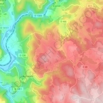
Name: Aubazines topographic map, elevation, terrain.
Average elevation: 1,165 ft
Minimum elevation: 430 ft
Maximum elevation: 1,798 ft
Make a donation
Gear up for your next adventure:
As an Amazon Associate, this site earns from qualifying purchases at no extra cost to you.
Other topographic maps
Click on a map to view its topography, its elevation and its terrain.
La Combe Perouze
France > Nouvelle-Aquitaine > Corrèze > Orgnac-sur-Vézère
Average elevation: 1,076 ft
Make a donation
Gear up for your next adventure:
As an Amazon Associate, this site earns from qualifying purchases at no extra cost to you.
Make a donation
Gear up for your next adventure:
As an Amazon Associate, this site earns from qualifying purchases at no extra cost to you.
Make a donation
Gear up for your next adventure:
As an Amazon Associate, this site earns from qualifying purchases at no extra cost to you.
Make a donation
Gear up for your next adventure:
As an Amazon Associate, this site earns from qualifying purchases at no extra cost to you.
La Nadalie
France > Nouvelle-Aquitaine > Corrèze > Saint-Pantaléon-de-Larche
Average elevation: 482 ft