
Make a donation
Gear up for your next adventure:
As an Amazon Associate, this site earns from qualifying purchases at no extra cost to you.
O Outeiro topographic map
Click on the map to display elevation.
Make a donation
Gear up for your next adventure:
As an Amazon Associate, this site earns from qualifying purchases at no extra cost to you.
About this map
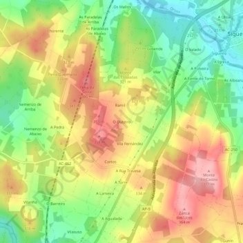
Name: O Outeiro topographic map, elevation, terrain.
Average elevation: 951 ft
Minimum elevation: 715 ft
Maximum elevation: 1,191 ft
Make a donation
Gear up for your next adventure:
As an Amazon Associate, this site earns from qualifying purchases at no extra cost to you.
Other topographic maps
Click on a map to view its topography, its elevation and its terrain.
Santiago de Compostela
Spain > Galicia > Santiago > Santiago de Compostela
According to a medieval legend, the remains of the apostle James, son of Zebedee were brought to Galicia for burial, where they were lost. Eight hundred years later the light of a bright star guided a shepherd, Pelagius the Hermit, who was watching his flock at night to the burial site in Santiago de…
Average elevation: 853 ft
O Campón do Milladoiro
Spain > Galicia > Santiago > Santiago de Compostela > As Moas de Arriba
Average elevation: 791 ft