
Dharni topographic map
Interactive map
Click on the map to display elevation.
About this map
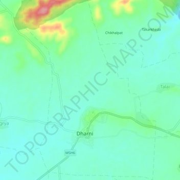
Name: Dharni topographic map, elevation, terrain.
Location: Dharni, Amravati, Maharashtra, India (21.54183 76.87378 21.58294 76.90661)
Average elevation: 1,073 ft
Minimum elevation: 981 ft
Maximum elevation: 1,358 ft
Other topographic maps
Click on a map to view its topography, its elevation and its terrain.
Harisal
India > Maharashtra > Dharni
Harisal, Dharni, Amravati, Maharashtra, India
Average elevation: 1,312 ft
Dudhani
India > Maharashtra > Dharni
Dudhani, Dharni, Amravati, Maharashtra, India
Average elevation: 1,263 ft