
Make a donation
Gear up for your next adventure:
As an Amazon Associate, this site earns from qualifying purchases at no extra cost to you.
Agta topographic map
Click on the map to display elevation.
Make a donation
Gear up for your next adventure:
As an Amazon Associate, this site earns from qualifying purchases at no extra cost to you.
About this map
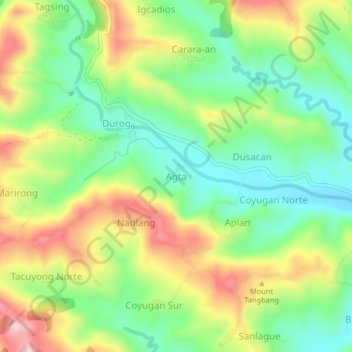
Name: Agta topographic map, elevation, terrain.
Location: Agta, Iloilo, Western Visayas, Philippines (10.80884 122.32012 10.84884 122.36012)
Average elevation: 728 ft
Minimum elevation: 377 ft
Maximum elevation: 1,234 ft
Make a donation
Gear up for your next adventure:
As an Amazon Associate, this site earns from qualifying purchases at no extra cost to you.
Other topographic maps
Click on a map to view its topography, its elevation and its terrain.
Make a donation
Gear up for your next adventure:
As an Amazon Associate, this site earns from qualifying purchases at no extra cost to you.
Santa Barbara Victory Plaza
Philippines > Iloilo > Santa Barbara > Angel's Point Subdivision
Average elevation: 108 ft