Geolocate

Dry Branch topographic map

Click on the map to display elevation.

About this map

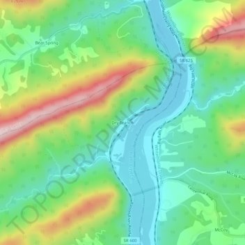
Name: Dry Branch topographic map, elevation, terrain.

Location: Dry Branch, Pulaski County, Virginia, 24058, United States (37.21457 -80.63812 37.25457 -80.59812)

Average elevation: 2,018 ft

Minimum elevation: 1,614 ft

Maximum elevation: 2,825 ft

Pulaski County trails, hiking, mountain biking, running and outdoor activities

Other topographic maps

Click on a map to view its topography, its elevation and its terrain.

Pulaski

United States > Virginia > Pulaski County

Average elevation: 2,133 ft

Hogan Lake

United States > Virginia > Pulaski County

Average elevation: 2,365 ft

Parrott

United States > Virginia > Pulaski County

Average elevation: 1,982 ft

Gear up for your next adventure:

🧼Biodegradable Camping Soap - Eco‑friendly soap for outdoor hygiene
🦟Ultrasonic Repellers - Create a bug-free zone at your camp or rest stop
🔌USB Car Charger - Car charger for on‑the‑go power needs
🚁Photography Drones - Capture stunning aerial views of landforms and topography
🧯Emergency Survival Kit - All‑in‑one survival essentials for the backcountry

As an Amazon Associate, this site earns from qualifying purchases at no extra cost to you.