Geolocate

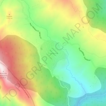
Samarina topographic map

Click on the map to display elevation.

Samarina

Samarina is located on an eastern spur of Mount Smolikas, the highest of the Pindus range and the second-highest mountain in all of Greece. At an altitude of 1380–1515 meters (4528' to 4970'), it is considered one of the highest villages in Greece and also one of the highest in the Balkans; its height puts it among soaring settlements such as: Aetomilitsa (Densko) and Seli (Selia).

Wikipedia (CC-BY-SA 3.0)

About this map

Name: Samarina topographic map, elevation, terrain.

Location: Samarina, Municipality of Grevena, Grevena Regional Unit, Western Macedonia, Epirus and Western Macedonia, 510 32, Greece (40.08443 20.99842 40.12443 21.03842)

Average elevation: 5,112 ft

Minimum elevation: 3,799 ft

Maximum elevation: 6,864 ft

Gear up for your next adventure:

📶Vehicle Signal Boosters - Improve reception in rural areas while driving to trailheads
Solar GPS Watches - Advanced multisport watches with built-in topographic maps
🧭Outdoor Navigation Book - Learn advanced navigation skills
🎒Day Hiking Backpack - Lightweight backpack perfect for day trips and outdoor adventures
📱Solar Portable Charger - Solar power bank for charging devices off‑grid

As an Amazon Associate, this site earns from qualifying purchases at no extra cost to you.