
Make a donation
Gear up for your next adventure:
As an Amazon Associate, this site earns from qualifying purchases at no extra cost to you.
Charlestown topographic map
Click on the map to display elevation.
Make a donation
Gear up for your next adventure:
As an Amazon Associate, this site earns from qualifying purchases at no extra cost to you.
About this map
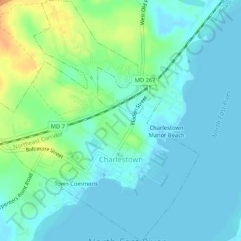
Name: Charlestown topographic map, elevation, terrain.
Location: Charlestown, Cecil County, Maryland, 21914, United States (39.56435 -75.99677 39.59198 -75.96326)
Average elevation: 30 ft
Minimum elevation: -7 ft
Maximum elevation: 115 ft
Cecil County trails, hiking, mountain biking, running and outdoor activities
Make a donation
Gear up for your next adventure:
As an Amazon Associate, this site earns from qualifying purchases at no extra cost to you.
Other topographic maps
Click on a map to view its topography, its elevation and its terrain.
Make a donation
Gear up for your next adventure:
As an Amazon Associate, this site earns from qualifying purchases at no extra cost to you.
Make a donation
Gear up for your next adventure:
As an Amazon Associate, this site earns from qualifying purchases at no extra cost to you.
Frenchtown
United States > Maryland > Cecil County > Perryville > Frenchtown
Average elevation: 115 ft