Geolocate

Tulung topographic map

Click on the map to display elevation.

About this map

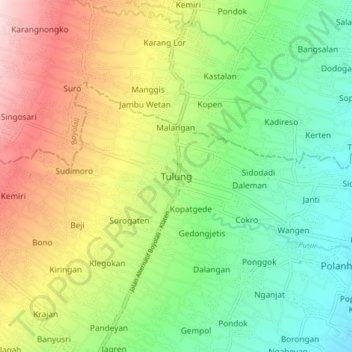
Name: Tulung topographic map, elevation, terrain.

Location: Tulung, Klaten, Central Java, Java, 57482, Indonesia (-7.63068 110.58113 -7.55068 110.66113)

Average elevation: 955 ft

Minimum elevation: 561 ft

Maximum elevation: 1,562 ft

Other topographic maps

Click on a map to view its topography, its elevation and its terrain.

Jaten

Indonesia > Central Java > Klaten

Average elevation: 384 ft

Bendo

Indonesia > Central Java > Klaten

Average elevation: 361 ft

Bulan

Indonesia > Central Java > Klaten

Average elevation: 394 ft

Depra Sentono

Indonesia > Central Java > Klaten

Average elevation: 335 ft

Pugeran

Indonesia > Central Java > Klaten

Average elevation: 318 ft

Kemalang

Indonesia > Central Java > Klaten

Average elevation: 2,769 ft

Sidorejo

Indonesia > Central Java > Klaten

Average elevation: 3,642 ft

Sajen

Indonesia > Central Java > Klaten

Average elevation: 344 ft

Taji

Indonesia > Central Java > Klaten

Average elevation: 315 ft

RT 11

Indonesia > Central Java > Klaten

Average elevation: 318 ft

Gear up for your next adventure:

🪑Portable Camp Table - Compact table for campsite meals
🔭Telescopic Hiking Pole - Adjustable pole for hiking stability
🥇GPS Hiking Watch - Multi‑sport GPS watch with navigation and trail tracking
🖼️Topo Map Wall Art - Decorative topographic prints of famous peaks and regions
🔭Compact Binoculars - HD vision for scouting terrain and identifying distant landmarks

As an Amazon Associate, this site earns from qualifying purchases at no extra cost to you.