
Make a donation
Gear up for your next adventure:
As an Amazon Associate, this site earns from qualifying purchases at no extra cost to you.
Guntur topographic map
Click on the map to display elevation.
Make a donation
Gear up for your next adventure:
As an Amazon Associate, this site earns from qualifying purchases at no extra cost to you.
Guntur
Guntur is located at 16°17′N 80°26′E / 16.29°N 80.43°E / 16.29; 80.43. It has an average elevation of 33 metres (108 ft) and is situated on the plains. There are few hills in the surrounding suburban areas and Perecherla Reserve Forest is located in the city's north-west. Guntur lies approximately 30 kilometres (19 mi) south of Amaravati, the capital of Andhra Pradesh.
Make a donation
Gear up for your next adventure:
As an Amazon Associate, this site earns from qualifying purchases at no extra cost to you.
About this map
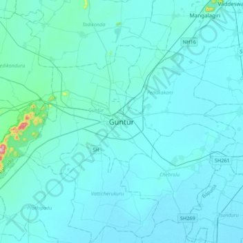
Name: Guntur topographic map, elevation, terrain.
Location: Guntur, Andhra Pradesh, 522001, India (16.13152 80.29416 16.45152 80.61416)
Average elevation: 95 ft
Minimum elevation: 20 ft
Maximum elevation: 1,555 ft
Make a donation
Gear up for your next adventure:
As an Amazon Associate, this site earns from qualifying purchases at no extra cost to you.
Other topographic maps
Click on a map to view its topography, its elevation and its terrain.