
Thank you for supporting this site ❤️
Make a donation
Make a donation
Gear up for your next adventure:
As an Amazon Associate, this site earns from qualifying purchases at no extra cost to you.
Mundakkai topographic map
Click on the map to display elevation.
Thank you for supporting this site ❤️
Make a donation
Make a donation
Gear up for your next adventure:
As an Amazon Associate, this site earns from qualifying purchases at no extra cost to you.
About this map
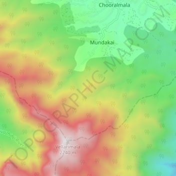
Name: Mundakkai topographic map, elevation, terrain.
Location: Mundakkai, Mundakai, Vythiri, Wayanad, Kerala, India (11.45136 76.12325 11.48907 76.18656)
Average elevation: 4,170 ft
Minimum elevation: 1,781 ft
Maximum elevation: 7,251 ft
Thank you for supporting this site ❤️
Make a donation
Make a donation
Gear up for your next adventure:
As an Amazon Associate, this site earns from qualifying purchases at no extra cost to you.