
Make a donation
Gear up for your next adventure:
As an Amazon Associate, this site earns from qualifying purchases at no extra cost to you.
Moya topographic map
Click on the map to display elevation.
Make a donation
Gear up for your next adventure:
As an Amazon Associate, this site earns from qualifying purchases at no extra cost to you.
About this map
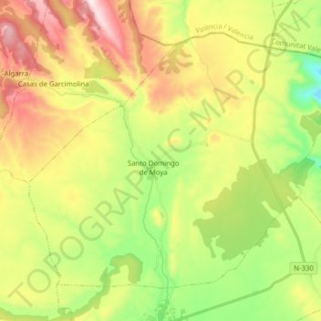
Name: Moya topographic map, elevation, terrain.
Location: Moya, Cuenca, Castile-La Mancha, Spain (39.92143 -1.43050 40.01667 -1.27434)
Average elevation: 3,625 ft
Minimum elevation: 2,615 ft
Maximum elevation: 4,931 ft
Make a donation
Gear up for your next adventure:
As an Amazon Associate, this site earns from qualifying purchases at no extra cost to you.
Other topographic maps
Click on a map to view its topography, its elevation and its terrain.
Make a donation
Gear up for your next adventure:
As an Amazon Associate, this site earns from qualifying purchases at no extra cost to you.
Alto Llano
Spain > Castile-La Mancha > Mancha Alta de Toledo > Quintanar de la Orden
Average elevation: 2,290 ft
Make a donation
Gear up for your next adventure:
As an Amazon Associate, this site earns from qualifying purchases at no extra cost to you.
Arenas
Spain > Castile-La Mancha > La Mancha > Alcázar de San Juan > Alameda de Cervera
Average elevation: 2,103 ft