Geolocate

Dit topographic map

Click on the map to display elevation.

About this map

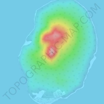
Name: Dit topographic map, elevation, terrain.

Location: Dit, Agutaya, Palawan, Mimaropa, 5320, Philippines (11.24415 120.93255 11.24425 120.93265)

Average elevation: 112 ft

Minimum elevation: 0 ft

Maximum elevation: 728 ft

Gear up for your next adventure:

📷Action Cameras - Rugged cameras to document your journeys across rugged terrain
📻Weather Alert Radios - Stay informed of storm risks while off-the-grid
🦶Hiking Gaiters - Keep debris and water out of your boots
📌Outdoor GPS Map App - Apps and devices for digital topographic navigation
📷Action Camera - Capture your outdoor adventures in HD

As an Amazon Associate, this site earns from qualifying purchases at no extra cost to you.