Geolocate

Oza topographic map

Click on the map to display elevation.

About this map

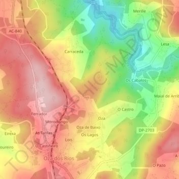
Name: Oza topographic map, elevation, terrain.

Location: Oza, Oza-Cesuras, Betanzos, A Coruña, Galicia, Spain (43.21177 -8.19354 43.24017 -8.15690)

Average elevation: 604 ft

Minimum elevation: 184 ft

Maximum elevation: 915 ft

Other topographic maps

Click on a map to view its topography, its elevation and its terrain.

Quistilan

Spain > Galicia > Betanzos

Average elevation: 554 ft

Burricios

Spain > Galicia > Betanzos > Oza-Cesuras

Average elevation: 876 ft

Tiúlfe

Spain > Galicia > Betanzos

Average elevation: 928 ft

Ansimonde

Spain > Galicia > Betanzos > Miño

Average elevation: 492 ft

As Brañas

Spain > Galicia > Betanzos > O Pazo de Irixoa

Average elevation: 1,243 ft

Cendá

Spain > Galicia > Betanzos

Average elevation: 817 ft

Cesuras

Spain > Galicia > Betanzos

Average elevation: 1,043 ft

Miño

Spain > Galicia > Betanzos

Average elevation: 135 ft

Gear up for your next adventure:

🧯Portable Fire Pit - Compact fire pit for camping spots
🥘Titanium Cookware - Durable, featherlight pots and pans for backpacking
🎒Trail Energy Bars - High‑calorie bars for hiking energy
📡Handheld GPS Device - Reliable handheld GPS for outdoor navigation
📦Dry Bags Set - Waterproof storage for electronics and clothes

As an Amazon Associate, this site earns from qualifying purchases at no extra cost to you.