
Make a donation
Gear up for your next adventure:
As an Amazon Associate, this site earns from qualifying purchases at no extra cost to you.
Strande topographic map
Click on the map to display elevation.
Make a donation
Gear up for your next adventure:
As an Amazon Associate, this site earns from qualifying purchases at no extra cost to you.
About this map
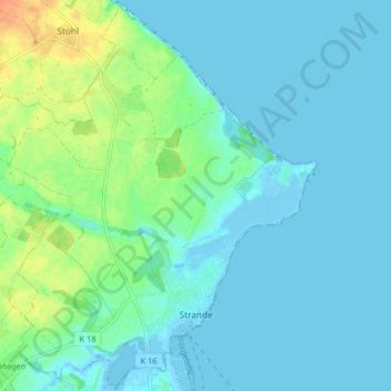
Name: Strande topographic map, elevation, terrain.
Average elevation: 26 ft
Minimum elevation: -16 ft
Maximum elevation: 128 ft
Make a donation
Gear up for your next adventure:
As an Amazon Associate, this site earns from qualifying purchases at no extra cost to you.
Other topographic maps
Click on a map to view its topography, its elevation and its terrain.
Ramsdorf
Deutschland > Schleswig-Holstein > Kreis Rendsburg-Eckernförde > Owschlag
Average elevation: 52 ft
Aukrug
Deutschland > Schleswig-Holstein > Kreis Rendsburg-Eckernförde
Die Gemeinde ist ein staatlich anerkannter Erholungsort und liegt im Herzen des 380 km² großen Naturparks Aukrug mit Wiesen und Feldern, Heide, Mooren, Teichen und kleinen Flussläufen. Durch den Abbau von Torf und der anschließenden Herstellung von Torfkohle, die ähnlich wie Holzkohle hergestellt wird,…
Average elevation: 75 ft
Dänisch-Nienhof
Deutschland > Schleswig-Holstein > Kreis Rendsburg-Eckernförde
Average elevation: 56 ft
Make a donation
Gear up for your next adventure:
As an Amazon Associate, this site earns from qualifying purchases at no extra cost to you.
Rohrüh
Deutschland > Schleswig-Holstein > Kreis Rendsburg-Eckernförde > Schuby
Average elevation: 30 ft
Trömbek
Deutschland > Schleswig-Holstein > Kreis Rendsburg-Eckernförde > Lehmkuhl
Average elevation: 66 ft
Make a donation
Gear up for your next adventure:
As an Amazon Associate, this site earns from qualifying purchases at no extra cost to you.
Neu-Bülk
Deutschland > Schleswig-Holstein > Kreis Rendsburg-Eckernförde > Rabendorf
Average elevation: 85 ft
Knoop
Deutschland > Schleswig-Holstein > Kreis Rendsburg-Eckernförde > Altenholz
Average elevation: 59 ft
Guckelsby
Deutschland > Schleswig-Holstein > Kreis Rendsburg-Eckernförde > Sieseby
Average elevation: 43 ft
Make a donation
Gear up for your next adventure:
As an Amazon Associate, this site earns from qualifying purchases at no extra cost to you.
Norby
Deutschland > Schleswig-Holstein > Kreis Rendsburg-Eckernförde > Rieseby
Average elevation: 69 ft
Osselberg
Deutschland > Schleswig-Holstein > Kreis Rendsburg-Eckernförde > Blumenthal
Average elevation: 128 ft
Make a donation
Gear up for your next adventure:
As an Amazon Associate, this site earns from qualifying purchases at no extra cost to you.
Aschberg
Deutschland > Schleswig-Holstein > Kreis Rendsburg-Eckernförde > Ascheffel
Average elevation: 128 ft
Glüsing
Deutschland > Schleswig-Holstein > Kreis Rendsburg-Eckernförde > Hohenwestedt
Average elevation: 125 ft
Make a donation
Gear up for your next adventure:
As an Amazon Associate, this site earns from qualifying purchases at no extra cost to you.
Make a donation
Gear up for your next adventure:
As an Amazon Associate, this site earns from qualifying purchases at no extra cost to you.
Bössel
Deutschland > Schleswig-Holstein > Kreis Rendsburg-Eckernförde > Nübbel
Average elevation: 20 ft