
Make a donation
Gear up for your next adventure:
As an Amazon Associate, this site earns from qualifying purchases at no extra cost to you.
Reninge topographic map
Click on the map to display elevation.
Make a donation
Gear up for your next adventure:
As an Amazon Associate, this site earns from qualifying purchases at no extra cost to you.
Reninge
Reninge ligt in het poldergebied op de rand van Zandlemig Vlaanderen, op een hoogte van ongeveer 5 meter. In het noorden loopt de IJzer met de Reningebrug. In het oosten vindt men de Kemmelbeek die ten noorden van de kom uitmondt in de IJzer. Verdere waterlopen zijn Meersbeek en Boezingegracht.
Make a donation
Gear up for your next adventure:
As an Amazon Associate, this site earns from qualifying purchases at no extra cost to you.
About this map
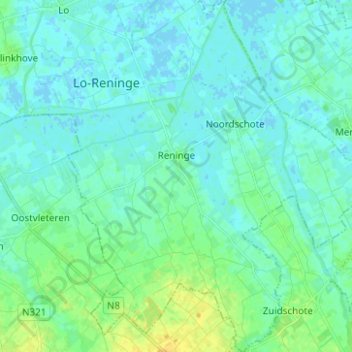
Name: Reninge topographic map, elevation, terrain.
Location: Reninge, Lo-Reninge, Diksmuide, West-Vlaanderen, België (50.90354 2.75059 50.98201 2.82630)
Average elevation: 16 ft
Minimum elevation: -7 ft
Maximum elevation: 62 ft
Make a donation
Gear up for your next adventure:
As an Amazon Associate, this site earns from qualifying purchases at no extra cost to you.
Other topographic maps
Click on a map to view its topography, its elevation and its terrain.