Geolocate

Topolovgrad topographic map

Click on the map to display elevation.

About this map

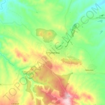
Name: Topolovgrad topographic map, elevation, terrain.

Location: Topolovgrad, Haskovo, 6560, Bulgaria (42.04474 26.29207 42.12474 26.37207)

Average elevation: 1,014 ft

Minimum elevation: 541 ft

Maximum elevation: 1,713 ft

Other topographic maps

Click on a map to view its topography, its elevation and its terrain.

Svilengrad

Bulgaria > Haskovo

Average elevation: 318 ft

Gear up for your next adventure:

🔦LED Headlamp - Bright and durable LED headlamp for night navigation
🧣Hiking Neck Gaiter - Multi‑use neck protection for outdoor weather
🗺️Topographic Maps - Detailed topo maps for hiking, exploring and outdoor navigation
📚USA Hiking Guide Books - Top trail guides and map books
🔊Portable Camp Speaker - Music and alerts at camp

As an Amazon Associate, this site earns from qualifying purchases at no extra cost to you.