Geolocate

Tanarrio topographic map

Click on the map to display elevation.

About this map

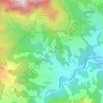
Name: Tanarrio topographic map, elevation, terrain.

Location: Tanarrio, Camaleño, Cantabria, 39587, Spain (43.13825 -4.72810 43.17825 -4.68810)

Average elevation: 2,657 ft

Minimum elevation: 1,250 ft

Maximum elevation: 5,538 ft

Gear up for your next adventure:

🪑Ultralight Camp Chairs - Portable seating for resting after a long day of mapping
📖Nature Tracking Books - Learn to track wildlife and terrain
GPS Sports Watch - GPS watch for running, hiking and training
Solar GPS Watches - Advanced multisport watches with built-in topographic maps
🌐World Map Poster - Decorative world maps with topographic info

As an Amazon Associate, this site earns from qualifying purchases at no extra cost to you.