Geolocate

Many Glacier topographic map

Click on the map to display elevation.

About this map

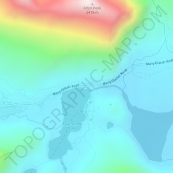
Name: Many Glacier topographic map, elevation, terrain.

Location: Many Glacier, Glacier County, Montana, United States (48.79042 -113.66757 48.81042 -113.64757)

Average elevation: 5,440 ft

Minimum elevation: 4,783 ft

Maximum elevation: 7,927 ft

Glacier County trails, hiking, mountain biking, running and outdoor activities

Other topographic maps

Click on a map to view its topography, its elevation and its terrain.

South Browning

United States > Montana > Glacier County

Average elevation: 4,413 ft

North Browning

United States > Montana > Glacier County

Average elevation: 4,383 ft

Shepard Glacier

United States > Montana > Glacier County

Average elevation: 7,077 ft

Cut Bank

United States > Montana > Glacier County

Cut Bank experiences a semi-arid climate (Köppen BSk), with long, cold, dry winters and short, warm, wetter summers. In winter, bitterly cold arctic air masses move south and impact the eastern side of the American Continental Divide. During such invasions, Cut Bank, with its comparatively high elevation and…

Average elevation: 3,763 ft

Pray Lake

United States > Montana > Glacier County

Average elevation: 5,633 ft

Cracker Lake

United States > Montana > Glacier County

Average elevation: 7,297 ft

Bullhead Lake

United States > Montana > Glacier County

Average elevation: 6,063 ft

Gear up for your next adventure:

🧼Biodegradable Camping Soap - Eco‑friendly soap for outdoor hygiene
💧Water Filtration Bottles - Safely drink from streams and lakes while exploring
🌡️Portable Weather Meter - Track weather conditions on the trail
🧭Orienteering Set - Complete compass and map reading kit
📚Navigation Handbooks - Master the art of reading topographic maps and using a compass

As an Amazon Associate, this site earns from qualifying purchases at no extra cost to you.