
Parque Santa Rosa topographic map
Click on the map to display elevation.
About this map
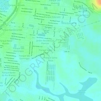
Name: Parque Santa Rosa topographic map, elevation, terrain.
Average elevation: 36 ft
Minimum elevation: 0 ft
Maximum elevation: 121 ft
Other topographic maps
Click on a map to view its topography, its elevation and its terrain.
Praça Cilenio Cesar Terra
Brasil > Rio de Janeiro > Campos dos Goytacazes > Travessão
Average elevation: 82 ft
Vila Nova de Campos
Brasil > Rio de Janeiro > Campos dos Goytacazes > Vila Nova de Campos
Average elevation: 210 ft
Santo Amaro de Campos
Brasil > Rio de Janeiro > Campos dos Goytacazes > Santo Amaro de Campos
Average elevation: 10 ft
Conceição do Imbé
Brasil > Rio de Janeiro > Campos dos Goytacazes > Morangaba
Average elevation: 282 ft
Pitangueiras
Brasil > Rio de Janeiro > Campos dos Goytacazes > Santo Amaro de Campos
Average elevation: 10 ft
Santo Eduardo
Brasil > Rio de Janeiro > Campos dos Goytacazes > Santo Eduardo
Average elevation: 256 ft