Geolocate

Protem topographic map

Click on the map to display elevation.

About this map

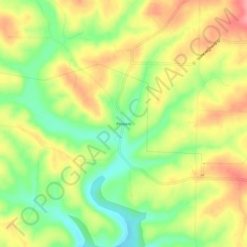
Name: Protem topographic map, elevation, terrain.

Location: Protem, Taney County, Missouri, 65733, United States (36.50895 -92.87878 36.54895 -92.83878)

Average elevation: 801 ft

Minimum elevation: 640 ft

Maximum elevation: 955 ft

Taney County trails, hiking, mountain biking, running and outdoor activities

Other topographic maps

Click on a map to view its topography, its elevation and its terrain.

Bradleyville

United States > Missouri > Taney County

Average elevation: 925 ft

Kirbyville

United States > Missouri > Taney County

Average elevation: 988 ft

Rockaway Beach

United States > Missouri > Taney County

Average elevation: 827 ft

Bull Creek

United States > Missouri > Taney County

Average elevation: 840 ft

Kirbyville

United States > Missouri > Taney County

Average elevation: 981 ft

Gear up for your next adventure:

🍳Camping Cook Set - Complete cookware for outdoor meals
🛡️Insect Repellent - Protection against bugs during outdoor activities
🪓Survival Multi‑Tool - Versatile tool for camp and trail tasks
🧢Sun Protection Hats - Wide-brimmed and UPF-rated hats for high-altitude sun safety
🧭Map Reading Tools - Tools and kits for map navigation

As an Amazon Associate, this site earns from qualifying purchases at no extra cost to you.