
Make a donation
Gear up for your next adventure:
As an Amazon Associate, this site earns from qualifying purchases at no extra cost to you.
Extertal topographic map
Click on the map to display elevation.
Make a donation
Gear up for your next adventure:
As an Amazon Associate, this site earns from qualifying purchases at no extra cost to you.
Extertal
Naturräumlich wird das Gemeindegebiet zum Lipper Bergland gezählt. Das Lipper Bergland ist stark gegliedert, im Gemeindegebiet wechseln sich bis zu fast 400 Meter hohe Kuppen und Höhenzüge, Niederungen und mit Tälern eingeschnittene Hügelgebiete ab. Der Hauptort Bösingfeld liegt umgeben von mehreren Höhenzügen im Bösingfelder Becken, einer hier verbreiterten Niederung im Tal der Exter. Nach Norden öffnet sich das Tal der Exter zum Rintelner Becken. Das Gemeindegebiet liegt wie alle lippischen Kommunen im Naturpark Teutoburger Wald / Eggegebirge. Im Osten und Norden grenzt das Gemeindegebiet an den vollständig in Niedersachsen liegenden Naturpark Weserbergland Schaumburg-Hameln.
Make a donation
Gear up for your next adventure:
As an Amazon Associate, this site earns from qualifying purchases at no extra cost to you.
About this map
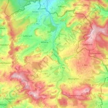
Name: Extertal topographic map, elevation, terrain.
Location: Extertal, Kreis Lippe, Nordrhein-Westfalen, 32699, Deutschland (52.03722 9.01949 52.14970 9.19403)
Average elevation: 748 ft
Minimum elevation: 256 ft
Maximum elevation: 1,276 ft
Make a donation
Gear up for your next adventure:
As an Amazon Associate, this site earns from qualifying purchases at no extra cost to you.
Other topographic maps
Click on a map to view its topography, its elevation and its terrain.
Vogelhorst
Deutschland > Nordrhein-Westfalen > Kreis Lippe > Lemgo > Voßheide
Average elevation: 469 ft
Make a donation
Gear up for your next adventure:
As an Amazon Associate, this site earns from qualifying purchases at no extra cost to you.