Geolocate

Untermeitingen topographic map

Click on the map to display elevation.

About this map
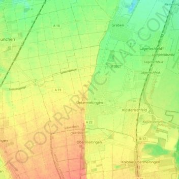
Name: Untermeitingen topographic map, elevation, terrain.

Location: Untermeitingen, Lechfeld, Augsburg (district), Bavaria, 86836, Germany (48.15011 10.77966 48.18195 10.87542)

Average elevation: 1,844 ft

Minimum elevation: 1,765 ft

Maximum elevation: 1,906 ft

Other topographic maps

Click on a map to view its topography, its elevation and its terrain.
Leuthau

Germany > Bavaria > Augsburg (district) > Schwabmünchen > Klimmach

Average elevation: 1,893 ft
Erlingen

Germany > Bavaria > Augsburg (district) > Meitingen

Average elevation: 1,427 ft

Gear up for your next adventure:

🧣Merino Neck Gaiters - Multi-functional headwear for wind and sun protection
🪑Ultralight Camp Chairs - Portable seating for resting after a long day of mapping
🎒Hydration Pack - Hands‑free water reservoir for long hikes
🔪Outdoor Multitools - Essential survival tools for gear repair and field use
🧢Sun Protection Hats - Wide-brimmed and UPF-rated hats for high-altitude sun safety

As an Amazon Associate, this site earns from qualifying purchases at no extra cost to you.