Geolocate

Faber topographic map

Click on the map to display elevation.

About this map

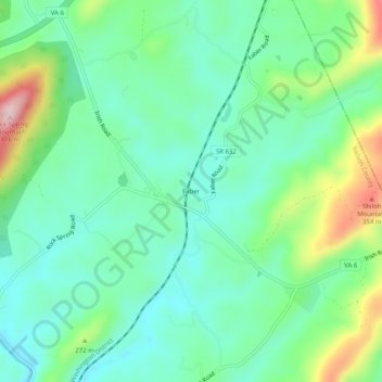
Name: Faber topographic map, elevation, terrain.

Location: Faber, Nelson County, Virginia, United States (37.81152 -78.75710 37.85152 -78.71710)

Average elevation: 696 ft

Minimum elevation: 446 ft

Maximum elevation: 1,322 ft

Nelson County trails, hiking, mountain biking, running and outdoor activities

Other topographic maps

Click on a map to view its topography, its elevation and its terrain.

Wintergreen

United States > Virginia > Nelson County > Wintergreen

Average elevation: 2,310 ft

Afton

United States > Virginia > Nelson County > Afton

Average elevation: 1,155 ft

Nellysford

United States > Virginia > Nelson County > Nellysford

Average elevation: 1,302 ft

Lovingston

United States > Virginia > Nelson County > Lovingston

Average elevation: 1,037 ft

Schuyler

United States > Virginia > Nelson County

Average elevation: 502 ft

Wintergreen

United States > Virginia > Nelson County > Wintergreen

Average elevation: 2,310 ft

Wintergreen

United States > Virginia > Nelson County > Wintergreen

Average elevation: 2,310 ft

Wintergreen

United States > Virginia > Nelson County > Wintergreen

Average elevation: 2,310 ft

Afton

United States > Virginia > Nelson County > Afton

Average elevation: 1,155 ft

Gear up for your next adventure:

🧭Compass with Lanyard - Easy‑carry compass for navigation
📶Vehicle Signal Boosters - Improve reception in rural areas while driving to trailheads
😴Insulated Sleeping Pads - Compact and warm pads for high-elevation camping
🧺Microfiber Travel Towels - Compact and fast-drying towels for trail use
📱Heavy-Duty Phone Cases - Drop-proof and waterproof protection for outdoor navigation

As an Amazon Associate, this site earns from qualifying purchases at no extra cost to you.