
Thank you for supporting this site ❤️
Make a donation
Make a donation
Gear up for your next adventure:
As an Amazon Associate, this site earns from qualifying purchases at no extra cost to you.
Warndt topographic map
Click on the map to display elevation.
Thank you for supporting this site ❤️
Make a donation
Make a donation
Gear up for your next adventure:
As an Amazon Associate, this site earns from qualifying purchases at no extra cost to you.
About this map
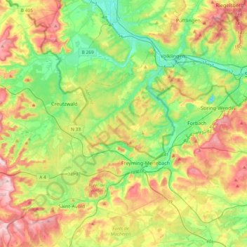
Name: Warndt topographic map, elevation, terrain.
Location: Warndt, Communauté régionale de Sarrebruck, Sarre, Allemagne (49.09837 6.59423 49.27265 6.96602)
Average elevation: 869 ft
Minimum elevation: 554 ft
Maximum elevation: 1,355 ft
Thank you for supporting this site ❤️
Make a donation
Make a donation
Gear up for your next adventure:
As an Amazon Associate, this site earns from qualifying purchases at no extra cost to you.
Other topographic maps
Click on a map to view its topography, its elevation and its terrain.
La Sarre
Allemagne > Sarre > Communauté régionale de Sarrebruck > Sarrebruck
Average elevation: 741 ft