
Enviny topographic map
Interactive map
Click on the map to display elevation.
About this map
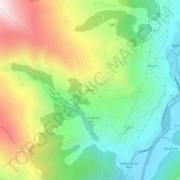
Name: Enviny topographic map, elevation, terrain.
Location: Enviny, Sort, Pallars Sobirá, Lérida, Cataluña, 25560, España (42.38152 1.08404 42.42152 1.12404)
Average elevation: 3,629 ft
Minimum elevation: 2,136 ft
Maximum elevation: 6,109 ft
Other topographic maps
Click on a map to view its topography, its elevation and its terrain.
Sort
España > Cataluña > Pallars Sobirá > Sort
Sort, Pallars Sobirá, Lérida, Cataluña, 25560, España
Average elevation: 5,056 ft