
Make a donation
Gear up for your next adventure:
As an Amazon Associate, this site earns from qualifying purchases at no extra cost to you.
Eureka topographic map
Click on the map to display elevation.
Make a donation
Gear up for your next adventure:
As an Amazon Associate, this site earns from qualifying purchases at no extra cost to you.
Eureka
Eureka is located in northern Juab County at 39°57′18″N 112°6′59″W / 39.95500°N 112.11639°W / 39.95500; -112.11639 (39.954974, -112.116364). It sits in the East Tintic Mountains at an elevation of 6,430 feet (1,960 m) above sea level. The northeast boundary of the city is the Utah County line, following the height of land. 7,828-foot (2,386 m) Packard Peak is to the north, while 8,048-foot (2,453 m) Godiva Mountain and 7,917-foot (2,413 m) Eureka Ridge are to the south.
Make a donation
Gear up for your next adventure:
As an Amazon Associate, this site earns from qualifying purchases at no extra cost to you.
About this map
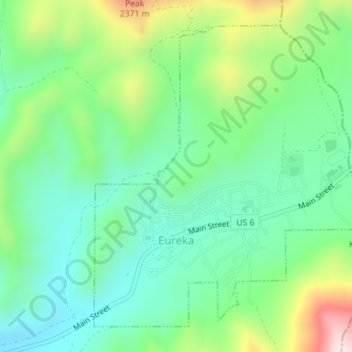
Name: Eureka topographic map, elevation, terrain.
Location: Eureka, Juab County, Utah, United States (39.94749 -112.12847 39.97063 -112.09986)
Average elevation: 6,719 ft
Minimum elevation: 6,214 ft
Maximum elevation: 7,861 ft
Juab County trails, hiking, mountain biking, running and outdoor activities
Make a donation
Gear up for your next adventure:
As an Amazon Associate, this site earns from qualifying purchases at no extra cost to you.
Other topographic maps
Click on a map to view its topography, its elevation and its terrain.