
Neenah topographic map
Interactive map
Click on the map to display elevation.
About this map
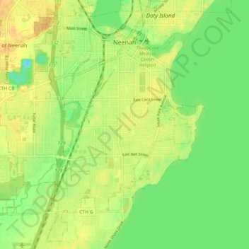
Name: Neenah topographic map, elevation, terrain.
Location: Neenah, Winnebago County, Wisconsin, 54956, United States (44.13440 -88.52362 44.19461 -88.43409)
Average elevation: 755 ft
Minimum elevation: 699 ft
Maximum elevation: 804 ft
Other topographic maps
Click on a map to view its topography, its elevation and its terrain.
Town of Nepeuskum
United States > Wisconsin > Winnebago County
Town of Nepeuskum, Winnebago County, Wisconsin, United States
Average elevation: 846 ft
Oshkosh
United States > Wisconsin > Winnebago County
Oshkosh, Winnebago County, Wisconsin, United States
Average elevation: 771 ft
Fox Crossing
United States > Wisconsin > Winnebago County
Fox Crossing, Winnebago County, Wisconsin, United States
Average elevation: 781 ft
Winneconne
United States > Wisconsin > Winnebago County
Winneconne, Winnebago County, Wisconsin, 54986, United States
Average elevation: 755 ft
Larsen
United States > Wisconsin > Winnebago County
Larsen, Town of Clayton, Winnebago County, Wisconsin, United States
Average elevation: 781 ft
Lake Poygan
United States > Wisconsin > Winnebago County
Lake Poygan, Town of Poygan, Winnebago County, Wisconsin, United States
Average elevation: 755 ft
Oshkosh
United States > Wisconsin > Winnebago County > Oshkosh
Oshkosh, Winnebago County, Wisconsin, 54903, United States
Average elevation: 784 ft