Geolocate

Agege topographic map

Click on the map to display elevation.

About this map

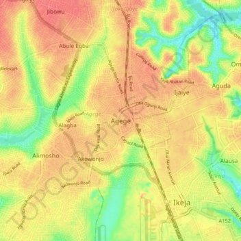
Name: Agege topographic map, elevation, terrain.

Location: Agege, Lagos State, 100282, Nigeria (6.58292 3.28034 6.66292 3.36034)

Average elevation: 121 ft

Minimum elevation: 13 ft

Maximum elevation: 190 ft

Gear up for your next adventure:

😴Insulated Sleeping Pads - Compact and warm pads for high-elevation camping
👓Polarized Sunglasses - Outdoor sunglasses for glare reduction
🔋Rechargeable Batteries - Power up your outdoor devices
🪶Wildlife Field Guides - Learn animal tracking and species ID
🎒Waterproof Dry Bags - Keep your electronics and maps dry inside your pack

As an Amazon Associate, this site earns from qualifying purchases at no extra cost to you.