
Make a donation
Gear up for your next adventure:
As an Amazon Associate, this site earns from qualifying purchases at no extra cost to you.
Condrieu topographic map
Click on the map to display elevation.
Make a donation
Gear up for your next adventure:
As an Amazon Associate, this site earns from qualifying purchases at no extra cost to you.
Condrieu
It is situated on the right bank of the Rhône, some 11 km (6.8 mi) south of Vienne and 44 km south of Lyon, at the foot of the lower slopes of the Mont Monnet. It has an area of 921 hectares and in 2018 it had a population of 3,927. Its altitude ranges from 146 to 460 metres.
Make a donation
Gear up for your next adventure:
As an Amazon Associate, this site earns from qualifying purchases at no extra cost to you.
About this map
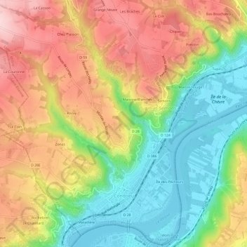
Name: Condrieu topographic map, elevation, terrain.
Average elevation: 873 ft
Minimum elevation: 463 ft
Maximum elevation: 1,332 ft
Make a donation
Gear up for your next adventure:
As an Amazon Associate, this site earns from qualifying purchases at no extra cost to you.