
La Merced topographic map
Click on the map to display elevation.
About this map
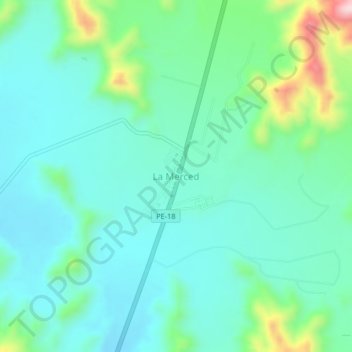
Name: La Merced topographic map, elevation, terrain.
Location: La Merced, Sayán, Huaura, Lima, Perú (-11.23985 -77.33132 -11.19985 -77.29132)
Average elevation: 1,749 ft
Minimum elevation: 1,506 ft
Maximum elevation: 2,602 ft
Other topographic maps
Click on a map to view its topography, its elevation and its terrain.
Sayán
La Comunidad Campesina de Sayán, se encuentra ubicada en la Región Lima, Provincia de Huaura, Distrito de Sayán. En la Región Costa y parte de la región Interandina con respecto a la región Costa sus límites se encuentran inscritos en el tomo 47 fojas del 77 al 79 de la partida electrónica Nº 8005504…
Average elevation: 4,852 ft