Geolocate

Schiffrain topographic map

Click on the map to display elevation.

About this map

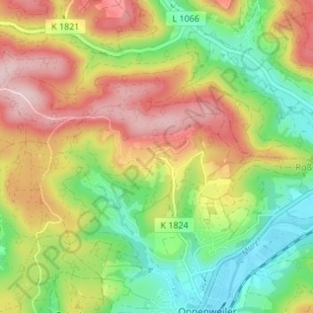
Name: Schiffrain topographic map, elevation, terrain.

Location: Schiffrain, Oppenweiler, VVG der Stadt Backnang, Rems-Murr-Kreis, Baden-Württemberg, 71570, Deutschland (48.98435 9.43094 49.02435 9.47094)

Average elevation: 1,207 ft

Minimum elevation: 843 ft

Maximum elevation: 1,640 ft

Other topographic maps

Click on a map to view its topography, its elevation and its terrain.

Gear up for your next adventure:

📷Action Camera - Capture your outdoor adventures in HD
🔌Solar Panel Charger - Charge gear sustainably outdoors
🌲Outdoor Survival Books - Best books on survival skills
🔭Compact Binoculars - HD vision for scouting terrain and identifying distant landmarks
🎒Trekking Poles - Sturdy poles for balance and stability on rough terrain

As an Amazon Associate, this site earns from qualifying purchases at no extra cost to you.