
Cauldon topographic map
Click on the map to display elevation.
About this map
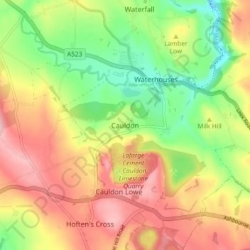
Name: Cauldon topographic map, elevation, terrain.
Average elevation: 928 ft
Minimum elevation: 650 ft
Maximum elevation: 1,201 ft
Other topographic maps
Click on a map to view its topography, its elevation and its terrain.
Forsbrook
United Kingdom > England > Staffordshire > Staffordshire Moorlands
Average elevation: 623 ft
Cheddleton
United Kingdom > England > Staffordshire > Staffordshire Moorlands
Average elevation: 669 ft