
Make a donation
Gear up for your next adventure:
As an Amazon Associate, this site earns from qualifying purchases at no extra cost to you.
Santa Cruz River topographic map
Click on the map to display elevation.
Make a donation
Gear up for your next adventure:
As an Amazon Associate, this site earns from qualifying purchases at no extra cost to you.
About this map
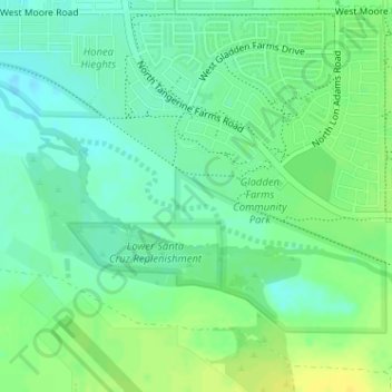
Name: Santa Cruz River topographic map, elevation, terrain.
Average elevation: 1,998 ft
Minimum elevation: 1,969 ft
Maximum elevation: 2,037 ft
Pima County trails, hiking, mountain biking, running and outdoor activities
Make a donation
Gear up for your next adventure:
As an Amazon Associate, this site earns from qualifying purchases at no extra cost to you.
Other topographic maps
Click on a map to view its topography, its elevation and its terrain.
Saguaro National Park - Tucson Mountain District
United States > Arizona > Pima County > Marana
Both districts conserve tracts of the Sonoran Desert, including ranges of significant hills, the Tucson Mountains in the west and the Rincon Mountains in the east. Elevations in the Tucson Mountain District range from 2,180 to 4,687 feet (664 to 1,429 m), the summit of Wasson Peak. Elevations within the Rincon…
Average elevation: 2,605 ft