
Make a donation
Gear up for your next adventure:
As an Amazon Associate, this site earns from qualifying purchases at no extra cost to you.
Eriste topographic map
Click on the map to display elevation.
Make a donation
Gear up for your next adventure:
As an Amazon Associate, this site earns from qualifying purchases at no extra cost to you.
Eriste
La localidad se encuentra a una altitud de 1118 m s. n. m.. En su término aflora un manantial de aguas ferruginosas.
Make a donation
Gear up for your next adventure:
As an Amazon Associate, this site earns from qualifying purchases at no extra cost to you.
About this map
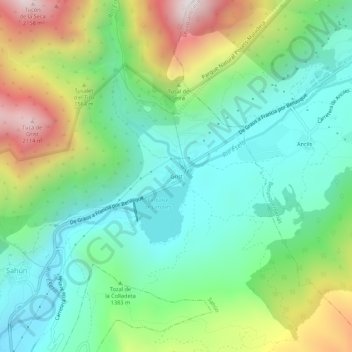
Name: Eriste topographic map, elevation, terrain.
Location: Eriste, Sahún, Ribagorza, Huesca, Aragón, 22468, España (42.56716 0.46985 42.60716 0.50985)
Average elevation: 4,508 ft
Minimum elevation: 3,320 ft
Maximum elevation: 7,018 ft
Make a donation
Gear up for your next adventure:
As an Amazon Associate, this site earns from qualifying purchases at no extra cost to you.
Other topographic maps
Click on a map to view its topography, its elevation and its terrain.
Make a donation
Gear up for your next adventure:
As an Amazon Associate, this site earns from qualifying purchases at no extra cost to you.