
Make a donation
Gear up for your next adventure:
As an Amazon Associate, this site earns from qualifying purchases at no extra cost to you.
Sivry-Rance topographic map
Click on the map to display elevation.
Make a donation
Gear up for your next adventure:
As an Amazon Associate, this site earns from qualifying purchases at no extra cost to you.
About this map
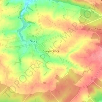
Name: Sivry-Rance topographic map, elevation, terrain.
Average elevation: 774 ft
Minimum elevation: 623 ft
Maximum elevation: 883 ft
Make a donation
Gear up for your next adventure:
As an Amazon Associate, this site earns from qualifying purchases at no extra cost to you.
Other topographic maps
Click on a map to view its topography, its elevation and its terrain.
Merbes-le-Château
België > Henegouwen > Thuin
Merbes-le-Château ligt aan de Sambre. De hoogte aan de kerk bedraagt 133 meter.
Average elevation: 515 ft
Make a donation
Gear up for your next adventure:
As an Amazon Associate, this site earns from qualifying purchases at no extra cost to you.
Make a donation
Gear up for your next adventure:
As an Amazon Associate, this site earns from qualifying purchases at no extra cost to you.
Make a donation
Gear up for your next adventure:
As an Amazon Associate, this site earns from qualifying purchases at no extra cost to you.
Beaumont
België > Henegouwen > Thuin
Beamont ligt betrekkelijk hoog. Het stadje ligt ook aan de Belgisch-Franse grens. De Hantes stroomt langs Beaumont. De hoogte aan de kerk bedraagt 221 meter.
Average elevation: 682 ft
Make a donation
Gear up for your next adventure:
As an Amazon Associate, this site earns from qualifying purchases at no extra cost to you.
Make a donation
Gear up for your next adventure:
As an Amazon Associate, this site earns from qualifying purchases at no extra cost to you.