
Thank you for supporting this site ❤️
Make a donation
Make a donation
Gear up for your next adventure:
As an Amazon Associate, this site earns from qualifying purchases at no extra cost to you.
Arak topographic map
Click on the map to display elevation.
Thank you for supporting this site ❤️
Make a donation
Make a donation
Gear up for your next adventure:
As an Amazon Associate, this site earns from qualifying purchases at no extra cost to you.
About this map
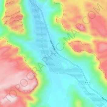
Name: Arak topographic map, elevation, terrain.
Location: Arak, In Amguel, de Tamanrasset District, Tamanrasset, Algeria (25.23898 3.74972 25.27898 3.78972)
Average elevation: 2,434 ft
Minimum elevation: 1,877 ft
Maximum elevation: 3,212 ft
Thank you for supporting this site ❤️
Make a donation
Make a donation
Gear up for your next adventure:
As an Amazon Associate, this site earns from qualifying purchases at no extra cost to you.