
Make a donation
Gear up for your next adventure:
As an Amazon Associate, this site earns from qualifying purchases at no extra cost to you.
Kaprijke topographic map
Click on the map to display elevation.
Make a donation
Gear up for your next adventure:
As an Amazon Associate, this site earns from qualifying purchases at no extra cost to you.
Kaprijke
Kaprijke maakt deel uit van de Vlaamse Zandstreek. Dit gebied is nagenoeg vlak, de hoogte schommelt tussen de 4 en 11 meter. In het zuidwesten is een iets meer uitgesproken microreliëf aanwezig dan in het noorden. De laagste delen zijn te vinden in het noorden van de deelgemeente.
Make a donation
Gear up for your next adventure:
As an Amazon Associate, this site earns from qualifying purchases at no extra cost to you.
About this map
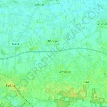
Name: Kaprijke topographic map, elevation, terrain.
Location: Kaprijke, Eeklo, Oost-Vlaanderen, Vlaanderen, België (51.16810 3.57474 51.24940 3.66508)
Average elevation: 13 ft
Minimum elevation: 0 ft
Maximum elevation: 43 ft
Make a donation
Gear up for your next adventure:
As an Amazon Associate, this site earns from qualifying purchases at no extra cost to you.
Other topographic maps
Click on a map to view its topography, its elevation and its terrain.