Geolocate

Northbrook topographic map

Interactive map

Click on the map to display elevation.

About this map

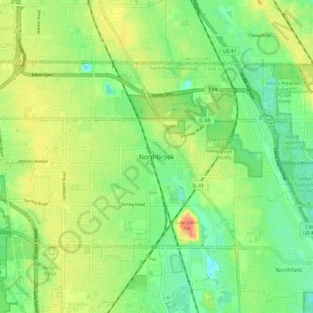
Name: Northbrook topographic map, elevation, terrain.

Location: Northbrook, Cook County, Illinois, 60062, United States (42.08870 -87.86651 42.16870 -87.78651)

Average elevation: 663 ft

Minimum elevation: 597 ft

Maximum elevation: 741 ft

Other topographic maps

Click on a map to view its topography, its elevation and its terrain.

Northbrook Manor

United States > Illinois > Cook County > Northbrook

Northbrook Manor, Northbrook, Northfield Township, Cook County, Illinois, 60062, United States

Average elevation: 663 ft

Northbrook Park

United States > Illinois > Cook County > Northbrook

Northbrook Park, Northbrook, Cook County, Illinois, 60062, United States

Average elevation: 666 ft