Geolocate

Zion Lodge topographic map

Click on the map to display elevation.

About this map

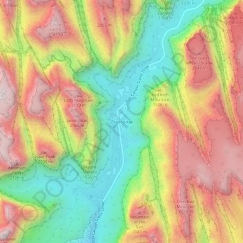
Name: Zion Lodge topographic map, elevation, terrain.

Location: Zion Lodge, Washington County, Utah, United States (37.22985 -112.97709 37.26985 -112.93709)

Average elevation: 5,650 ft

Minimum elevation: 4,144 ft

Maximum elevation: 7,139 ft

Other topographic maps

Click on a map to view its topography, its elevation and its terrain.

St. George

United States > Utah > Washington County

St. George, Washington County, Utah, United States

Average elevation: 3,048 ft

Zion National Park

United States > Utah > Washington County

Zion National Park, Washington County, Utah, United States

Average elevation: 6,158 ft

Kolob Reservoir

United States > Utah > Washington County

Kolob Reservoir, Washington County, Utah, United States

Average elevation: 8,199 ft

Washington

United States > Utah > Washington County

Washington, Washington County, Utah, 84780, United States

Average elevation: 3,031 ft

Mount Baldy

United States > Utah > Washington County

Mount Baldy, Washington County, Utah, United States

Average elevation: 7,717 ft

Virgin

United States > Utah > Washington County

Virgin, Washington County, Utah, United States

Average elevation: 4,104 ft

Hurricane Hill

United States > Utah > Washington County > Hurricane

Hurricane Hill, Hurricane, Washington County, Utah, 84745, United States

Average elevation: 3,524 ft

Pine Valley

United States > Utah > Washington County

Pine Valley, Washington County, Utah, 84781, United States

Average elevation: 6,808 ft

New Harmony

United States > Utah > Washington County

New Harmony, Washington County, Utah, United States

Average elevation: 5,367 ft

Bloomington Hill

United States > Utah > Washington County > St. George

Bloomington Hill, St. George, Washington County, Utah, 84770-1858, United States

Average elevation: 2,657 ft

Hurricane

United States > Utah > Washington County

Hurricane, Washington County, Utah, United States

Average elevation: 3,786 ft

Hurricane

United States > Utah > Washington County

Hurricane, Washington County, Utah, 84745, United States

Average elevation: 3,527 ft

Santa Clara

United States > Utah > Washington County

Santa Clara, Washington County, Utah, United States

Average elevation: 2,900 ft

Springdale

United States > Utah > Washington County

Springdale, Washington County, Utah, 84767, United States

Average elevation: 4,426 ft

Central

United States > Utah > Washington County

Central, Washington County, Utah, 84722, United States

Average elevation: 5,367 ft

Watchman Trailhead

United States > Utah > Washington County > Springdale

Watchman Trailhead, Springdale, Washington County, Utah, 84767, United States

Average elevation: 4,318 ft

In order to remain free and to keep improving, this site uses cookies created by Google to compile visit statistics and display personalized advertisements.

How is the collected data used?