
Duxford topographic map
Click on the map to display elevation.
About this map
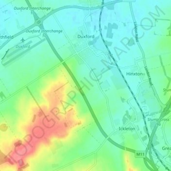
Name: Duxford topographic map, elevation, terrain.
Average elevation: 148 ft
Minimum elevation: 75 ft
Maximum elevation: 344 ft
Other topographic maps
Click on a map to view its topography, its elevation and its terrain.
Shepherd's Way
United Kingdom > England > Cambridgeshire > South Cambridgeshire
Average elevation: 52 ft
Icehouse
United Kingdom > England > Cambridgeshire > South Cambridgeshire > Babraham
Average elevation: 118 ft
(no name - just a patch of grass)
United Kingdom > England > Cambridgeshire > South Cambridgeshire > Waterbeach
Average elevation: 20 ft