Geolocate

Olden topographic map

Click on the map to display elevation.

About this map

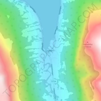
Name: Olden topographic map, elevation, terrain.

Location: Olden, Stryn, Vestland, 6788, Norway (61.81644 6.78639 61.85644 6.82639)

Average elevation: 1,289 ft

Minimum elevation: 0 ft

Maximum elevation: 4,518 ft

Gear up for your next adventure:

🕶️Glacier Sunglasses - Side shields to protect eyes from high-altitude snow glare
🌐World Map Poster - Decorative world maps with topographic info
👟Men's Trail Runners - Lightweight footwear for fast-paced exploration and light hiking
📶Vehicle Signal Boosters - Improve reception in rural areas while driving to trailheads
🧷Carabiner Set - Durable clips for gear attachment

As an Amazon Associate, this site earns from qualifying purchases at no extra cost to you.