Geolocate

Voss topographic map

Click on the map to display elevation.

About this map

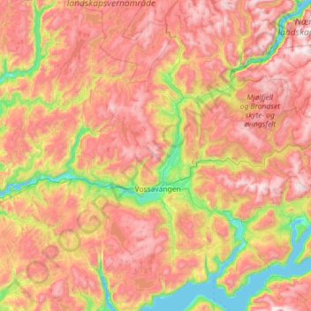
Name: Voss topographic map, elevation, terrain.

Location: Voss, Vestland, Norway (60.41451 5.84275 60.95955 6.98587)

Average elevation: 2,510 ft

Minimum elevation: 0 ft

Maximum elevation: 5,420 ft

Other topographic maps

Click on a map to view its topography, its elevation and its terrain.

Vossavangen

Norway > Vestland

Average elevation: 1,155 ft

Svelgen

Norway > Vestland

Average elevation: 705 ft

Sogndal

Norway > Vestland

Average elevation: 1,033 ft

Flåm

Norway > Vestland

Average elevation: 1,509 ft

Storen

Norway > Vestland

Average elevation: 5,722 ft

Undredal

Norway > Vestland

Average elevation: 1,335 ft

Høgalmane

Norway > Vestland

Average elevation: 1,772 ft

Vinjane

Norway > Vestland > Aurlandsvangen

Average elevation: 758 ft

Rognaldsvåg

Norway > Vestland

Average elevation: 46 ft

Bjørnafjorden

Norway > Vestland

Average elevation: 30 ft

Florø

Norway > Vestland

Average elevation: 46 ft

Flåm

Norway > Vestland > Flåm

Average elevation: 1,601 ft

Borgund

Norway > Vestland > Borgund

Average elevation: 2,539 ft

Preikestolen

Norway > Vestland

Average elevation: 860 ft

Maurstad

Norway > Vestland

Average elevation: 427 ft

Olden

Norway > Vestland > Olden

Average elevation: 1,289 ft

Heidi

Norway > Vestland > Lonevåg

Average elevation: 344 ft

Prest

Norway > Vestland

Average elevation: 3,996 ft

Ortnevik

Norway > Vestland

Average elevation: 735 ft

Gear up for your next adventure:

🧺Microfiber Travel Towels - Compact and fast-drying towels for trail use
🦺Reflective Outdoor Gear - Safety gear for low‑light conditions
🥘Titanium Cookware - Durable, featherlight pots and pans for backpacking
🔋Solar Power Banks - Keep your GPS and phone charged in remote wilderness areas
🌄Hiking Binoculars - Compact binoculars for scenic views and trail spotting

As an Amazon Associate, this site earns from qualifying purchases at no extra cost to you.