Geolocate

Chazuta topographic map

Click on the map to display elevation.

About this map

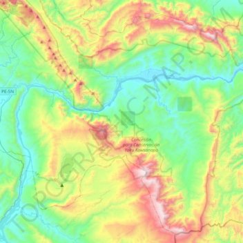
Name: Chazuta topographic map, elevation, terrain.

Location: Chazuta, Province of San Martín, San Martín, Peru (-6.81086 -76.16599 -6.46312 -75.78941)

Average elevation: 2,119 ft

Minimum elevation: 545 ft

Maximum elevation: 5,531 ft

Other topographic maps

Click on a map to view its topography, its elevation and its terrain.

Morro de Calzada

Peru > San Martín > Calzada > Calzada

Average elevation: 3,153 ft

Rey del Valle

Peru > San Martín > Alonso de Alvarado

Average elevation: 3,927 ft

Guantanamo

Peru > San Martín

Average elevation: 1,834 ft

San Andrés

Peru > San Martín > Jepelacio

Average elevation: 4,183 ft

La Unión

Peru > San Martín > La Banda de Shilcayo

Average elevation: 1,407 ft

Gear up for your next adventure:

📚USA Hiking Guide Books - Top trail guides and map books
🩹Survival Bandages - High‑quality bandages for emergencies
💧Water Filtration Bottles - Safely drink from streams and lakes while exploring
🔭Compact Binoculars - HD vision for scouting terrain and identifying distant landmarks
📚Navigation Handbooks - Master the art of reading topographic maps and using a compass

As an Amazon Associate, this site earns from qualifying purchases at no extra cost to you.